Two evacuation alerts remain as West Kootenay wildfires continue burning
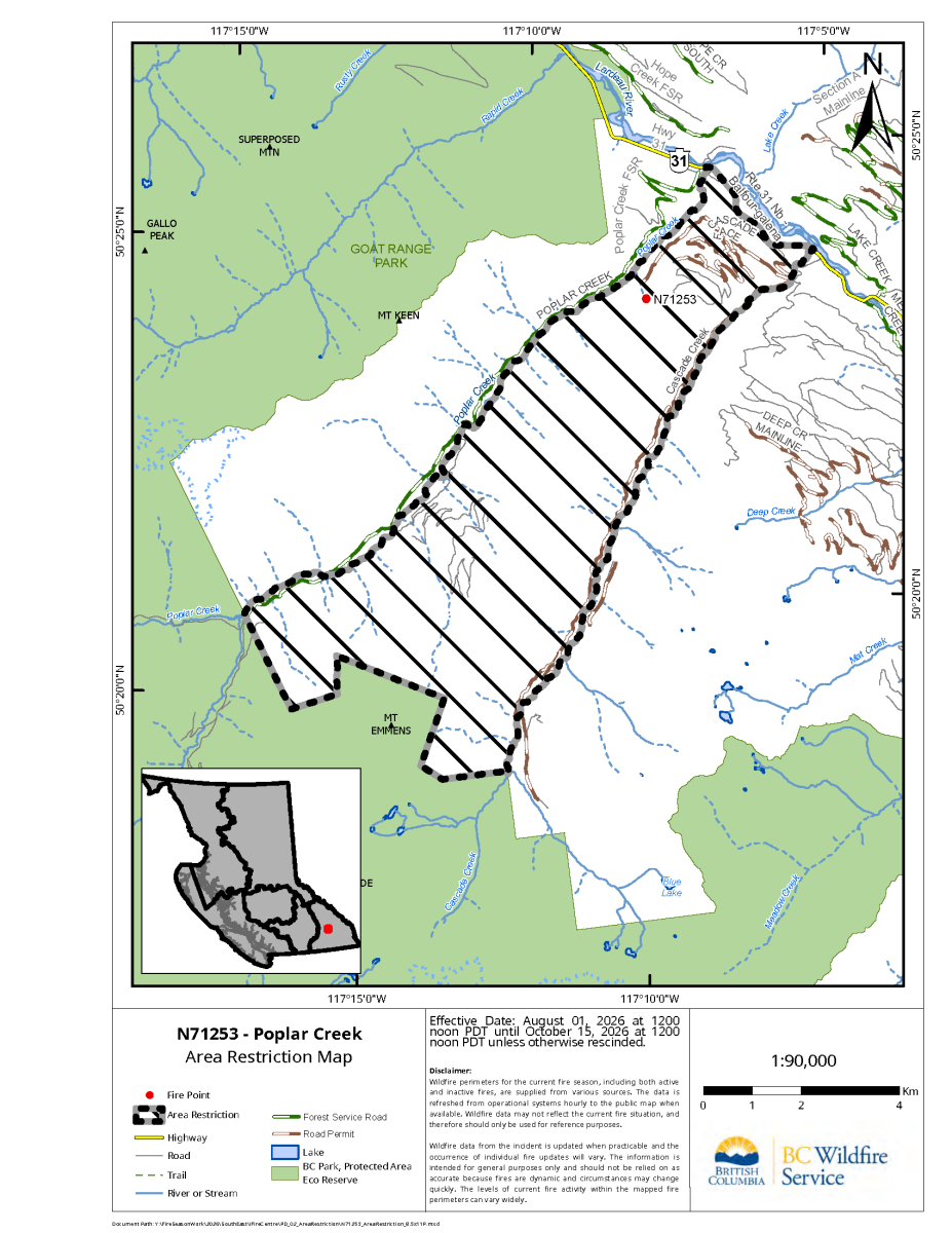
An area restriction remains in effect around the Poplar Creek wildfire north of Kaslo. The Regional District of Central Kootenay said Tuesday that the fire was approximately 162 hectares.
BC Wildfire Service map
WEST KOOTENAYS — No new evacuation alert or evacuation order was posted by the Regional District of Central Kootenay overnight, but two existing alerts remained active Tuesday as wildfires continued to burn in the West Kootenays.
The alerts are connected to the Poplar Creek wildfire in Electoral Area D and the Inonoaklin Creek wildfire in Electoral Area K. People under an evacuation alert are not required to leave immediately but should be prepared to evacuate on short notice.
The Poplar Creek alert covers 30 properties beginning at 15904 Highway 31 and continuing north through the community of Poplar Creek to Rapid Creek. The affected area is approximately 60 kilometres north of Kaslo in Electoral Area D.
The BC Wildfire Service continued to list the Poplar Creek fire as out of control Tuesday. It was estimated at approximately 162 hectares and was suspected to have been caused by lightning.
The RDCK issued the evacuation alert Saturday evening on the recommendation of the BC Wildfire Service. At that time, crews were constructing a control line on the eastern side of the fire before Highway 31, with aviation resources assigned to support the response.
An area restriction remains in effect around the Poplar Creek fire. It covers designated Crown land between Highway 31, Cascade Creek, the boundary of Goat Range Provincial Park and Poplar Creek. The restriction is scheduled to remain in place until noon on Oct. 15 unless it is rescinded earlier. Access to private property is permitted under the order.
Farther south, the Inonoaklin Creek evacuation alert applies to the property at 12212 Highway 6 and homes near Lightning Peak Road and Highway 6, northwest of the Needles ferry in Electoral Area K.
The fire was discovered July 25 and is suspected to have been caused by lightning. The BC Wildfire Service dashboard listed it as out of control and estimated it at approximately 1,136 hectares Tuesday. It was estimated at 597 hectares when the RDCK issued the evacuation alert July 28.
When the alert was issued, the RDCK reported that the fire was visible from Highway 6 but was not affecting the highway. Aircraft had been placing retardant and dropping water along the fire’s southern flank.
An area restriction also remains in effect around the Inonoaklin Creek fire. It restricts access to designated Crown land and is scheduled to remain in place until noon on Oct. 15 unless it is rescinded earlier. Exceptions listed in the order include travelling to or from a principal residence that is not under an evacuation order, using a highway, acting in an official capacity or supporting wildfire suppression and enforcement work.
Other fires remain out of control
Several other West Kootenay wildfires were listed as out of control by the BC Wildfire Service Tuesday.
The Mount Freya fire was estimated at approximately 367.8 hectares, while the Mount Rollins fire was estimated at 112 hectares. The Hope Creek North fire was listed at approximately 37 hectares, the Lew Creek fire at 26.7 hectares and the Evans Lake fire at 16 hectares.
The Evans Lake fire is in the Evans Lake Ecological Reserve within Valhalla Provincial Park, northwest of Slocan.
The Jumbo Creek wildfire is sometimes included in broader Southeast Fire Centre updates but is not in the West Kootenay. It is approximately 38 kilometres west of Invermere in the East Kootenay.
The Regional District of East Kootenay reported Sunday evening that Jumbo Creek was approximately 683.5 hectares. An area restriction remained in place, but the fire was not threatening structures or critical infrastructure at the time of that update.
No new evacuation alerts or evacuation orders for the Boundary region appeared among the current incidents listed by EmergencyInfoBC during the overnight reporting period.
Wildfire sizes and conditions can change as crews conduct additional assessments and receive updated aerial mapping. Residents near active fires should continue checking the BC Wildfire Service dashboard and their regional district’s emergency information page for current information.







Castlegar and Trail RCMP took several people into custody Tuesday while executing search warrants at properties in Robson and near Waneta as part of a joint drug-trafficking investigation.