Sinlahekin wildfire near Osoyoos grows to 73,794 acres
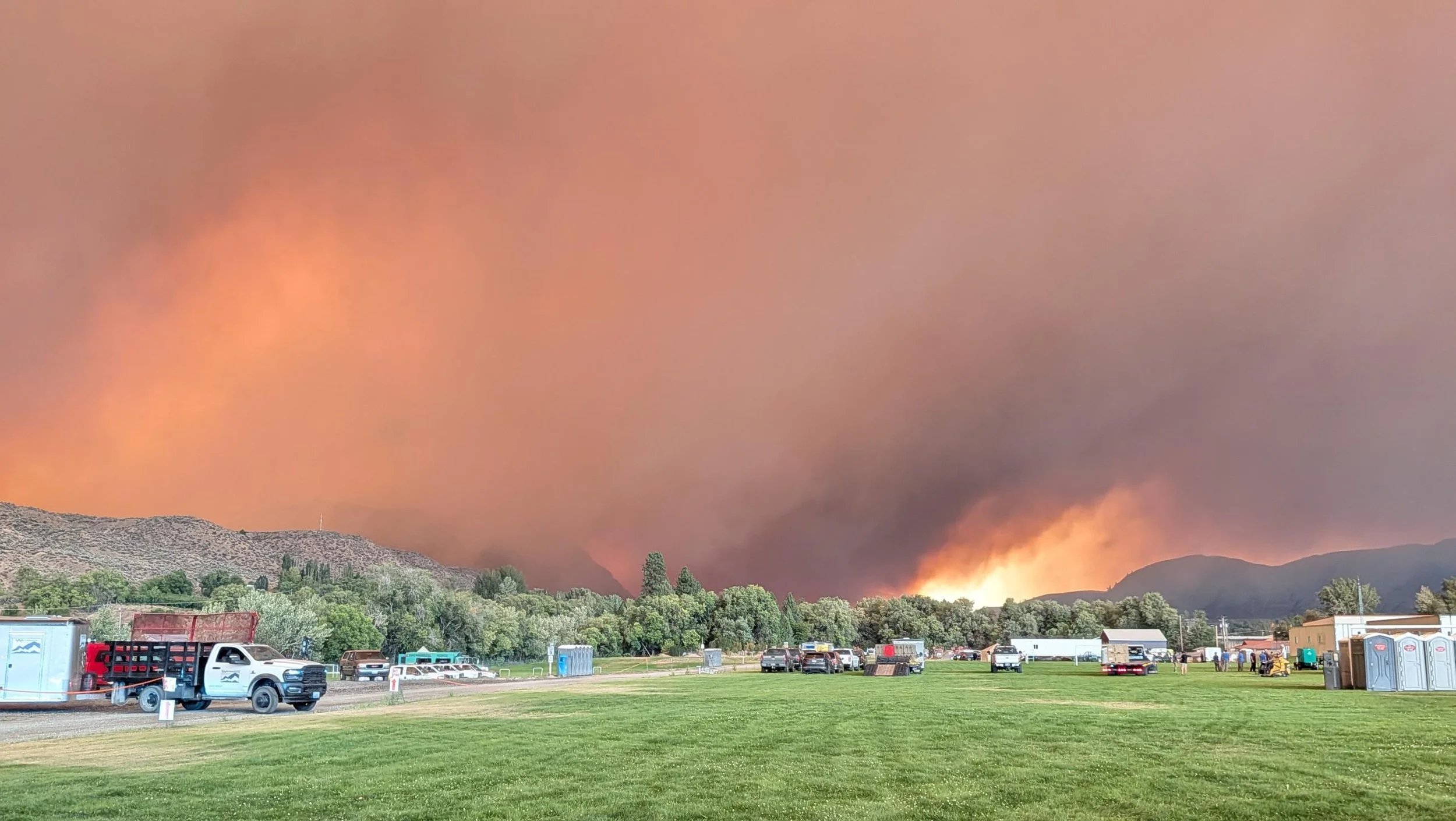
Small trucks and supplies stage in a green field with the Sinlahekin Fire smoke visible in the background on August 2, 2026. Submitted photo.
The Sinlahekin wildfire burning in northern Washington state has grown to 73,794 acres and remains completely uncontained after another period of rapid expansion.
The latest National Interagency Fire Center situation report recorded an increase of 37,526 acres. The fire now covers approximately 29,863 hectares and was listed at zero per cent containment Monday. A total of 828 firefighters and support personnel were assigned to the incident.
The fire is burning in Okanogan County west of Tonasket, south of the Canadian border and the communities of Oroville and Osoyoos.
Osoyoos Fire Rescue said in its most recent update that there was no immediate threat to the Town of Osoyoos. The Regional District of Okanagan-Similkameen is also monitoring the fire and has not asked residents on the Canadian side to take any action.
Fire grows by more than 37,000 acres in latest report
The Sinlahekin Fire was estimated at 24,380 acres Friday morning before strong winds drove significant growth through the weekend. By Monday, the mapped area had more than tripled. Official incident updates list the fire’s start date as July 26 and its cause as lightning or natural.
The National Interagency Fire Center reported active fire behaviour Monday, including wind-driven runs, short-range spotting and backing. Numerous residences and communications infrastructure remained threatened, with evacuations and road, trail and area closures in effect.
Okanogan County Emergency Management said Sunday night that the fire was particularly active near South Pine Creek, where it was pushing south and west. At 9:46 p.m., the fire was burning on the north side of South Pine Creek Road.
State Route 97 remained open at the time of that update, although several roads closer to the wildfire were closed and staffed by law-enforcement officers. Conconully was not under an evacuation notice.
Evacuations extend north toward Oroville
A Level 3 “Go Now” evacuation order remains in effect for areas west of the Okanogan River north toward Oroville, including Palmer Mountain.
The City of Oroville was placed under a Level 2 “Be Ready” notice. Residents under a Level 2 notice should be prepared to leave on short notice if conditions worsen.
Okanogan County has also issued Level 3 evacuation orders for several other areas during the fire, including Crumbacher Road, Lemanasky Road, North Lemanasky Road, Toby’s Mill Road and Horse Spring Coulee Road.
The Crumbacher Road order was issued early Sunday as the wind-driven fire moved southeast on Carter Mountain. County officials told residents in Level 3 areas not to wait for further notifications or door-to-door contact before leaving.
Evacuation boundaries have changed repeatedly as the fire has moved. Residents in Washington are being directed to use Okanogan County’s official evacuation map to check the current status of individual roads, properties and evacuation zones.
Shelters open in Tonasket and Omak
Two shelters remained open Sunday night for people displaced by the fire.
The Community Cultural Center at 411 South Western Avenue in Tonasket and the Omak Community Center at 601 Benton Street in Omak were accepting evacuees.
Okanogan County described air quality in the fire area as unhealthy and advised residents to limit outdoor activity and remain indoors as much as possible.
A limited number of electrical customers were without power Sunday night, although the county reported that the main transmission lines remained energized.
No action required in RDOS under latest official update
In its latest public advisory on the Sinlahekin Fire, issued July 31, the Regional District of Okanagan-Similkameen said no action was required from residents and that it was continuing to monitor the incident. Osoyoos Fire Rescue said in its Aug. 2 update that there was no immediate threat to the Town of Osoyoos
Conditions, evacuation boundaries and road access may change quickly. Residents should continue following Okanogan County Emergency Management, official Sinlahekin incident updates, Osoyoos Fire Rescue and the RDOS Emergency Operations Centre.


Grizzly Discoveries Inc. is seeking to raise up to $2 million as the company continues fall exploration across its Greenwood-area properties and prepares for drilling planned between October and December.