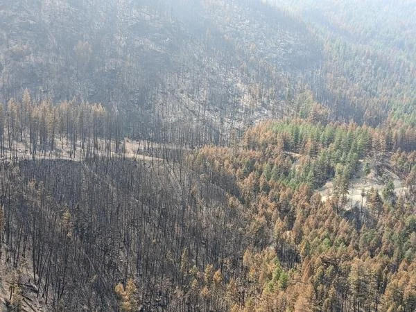
The Crater Creek wildfire burns near the Cathedral Lakes Lodge base camp in Electoral Area G on Aug. 24, 2023. Post-wildfire hazard assessments later identified landslide and debris-flow risks in parts of the Ashnola watershed.
RDOS photo.
Thunderstorms in the Lower Similkameen are putting renewed attention on landslide and debris-flow hazards in areas where the Lower Similkameen Indian Band has established an automated slope-monitoring system.
Environment Canada’s Monday afternoon forecast called for five to 10 millimetres of rain Tuesday in the Keremeos area, with a risk of thunderstorms over the ridges. Sunny conditions were forecast from Wednesday through Friday.
LSIB, working with WesTrek, has been implementing a slope-monitoring system on its lands to address landslides, erosion and slope instability in the Similkameen and Ashnola valleys.
The system has previously issued automated warnings when thunderstorms entered the ʔaysnúlaʔxʷ, or Ashnola, and c̓up̓áq̓, or Chopaka, areas. An LSIB notice published May 28 advised community members that thunderstorms had triggered the automated warning system in both areas.
The concern is backed by provincial post-wildfire hazard work following the 2023 Crater Creek wildfire.
A post-wildfire natural hazards assessment prepared for the B.C. government identified areas of high to very high risk in the region, including slopes and gullies above Ashnola Road, catchments in the lower Ashnola River watershed and fan areas along the west side of the Lower Similkameen River valley within or near several LSIB reserves.
The assessment found that loss of forest cover and changes to soils after wildfire can contribute to faster runoff and higher peak flows, along with erosion, landslides, debris flows and increased sediment movement.
It recommended greater monitoring and emergency preparedness, with strong consideration given to weather-based early-warning systems.
Those hazards have already produced problems following localized storms.
The assessment records a July 2, 2024 convective rainstorm that caused washouts along Crater Forest Service Road and sediment-laden flows through several channels into the Ashnola River. It also documents a debris flow at Swekust Creek during the summer or fall of 2024 that was likely triggered by a convective storm and temporarily blocked the Ashnola River.
The monitoring program could expand further.
Earlier this year, the Regional District of Okanagan-Similkameen supported an LSIB application for $252,000 through Indigenous Services Canada’s Emergency Management Assistance Program for 2026-27. The proposed work includes four static weather stations intended to strengthen the slope-monitoring and early-warning system.
Provincial emergency guidance says severe wildfires can affect soil stability, while heavy rainfall can increase the likelihood of landslides.
Possible warning signs include sudden changes in stream flow, unusually muddy water or pulses of sediment, new cracks in the ground, falling rocks and moving soil. People who encounter active slope movement are advised to move away from its path and call 911 when it is safe to do so.






Creston RCMP are warning residents and businesses after an increase in reported fuel thefts across the Creston Valley.