Smoke hangs over Grand Forks as regional wildfires force evacuations
This report is current to 7 p.m. PDT Sunday, Aug. 2, and uses official updates released between 7 p.m. PDT Saturday, Aug. 1, and 7 p.m. PDT Sunday. Times issued by East Kootenay authorities have been converted from Mountain Daylight Time to Pacific Daylight Time. East Kootenay is one hour ahead of Grand Forks during the summer.
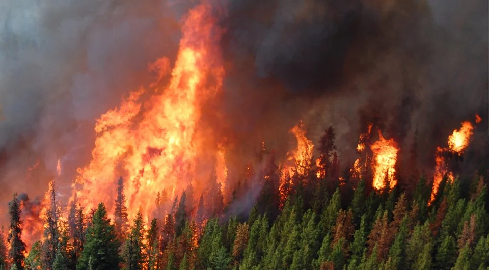
GRAND FORKS, B.C. — Smoke hangs over Grand Forks Sunday evening as wildfires force evacuations and affect roads in eastern Washington, the Okanagan and East Kootenay.
Grand Forks is not under an evacuation alert or order. No active emergency notice for the city or the Regional District of Kootenay Boundary appears on EmergencyInfoBC’s current wildfire list at the publication cutoff.
Environment Canada’s 3 p.m. PDT forecast calls for local smoke Sunday night, widespread smoke Monday and more local smoke Monday night.
A Grand Forks resident tells the Boundary Sentinel that smoke is heavy and conditions are very dry. Although he has received no evacuation notice, he is packing a go-bag in case conditions change.
No official update reviewed by the Sentinel identifies an active wildfire directly threatening Grand Forks. Environment Canada does not attribute the smoke over the city to a single fire.
Spokane fires prompt evacuation notices
The Spokane County Sheriff’s Office is grouping three incidents under the name “Spokane Fires”: the Old Trails Road Fire, Autumn Lane Fire and Fairview Road Fire.
The sheriff’s office directs residents to the Spokane Regional Emergency Communications map for current evacuation levels and boundaries. The Washington Department of Natural Resources also lists the Old Trails and Autumn Lane fires on its wildfire portal.
Spokane’s air quality is unhealthy Sunday evening. The Spokane Regional Clean Air Agency recorded an Air Quality Index of 198 at 6:35 p.m. PDT, with fine particulate matter as the predominant pollutant. An AQI between 151 and 200 falls within the agency’s unhealthy category.
The agency forecasts very unhealthy air for Monday. It says westerly winds are bringing smoke from Washington fires into Spokane Sunday, while north-northwest airflow is expected to bring additional smoke from fires in Washington and British Columbia Monday.
No figures for the number of evacuees, structures destroyed or power outages are included in this report because the Sentinel could not confirm those totals through a clearly time-stamped official update issued within the reporting period.
Okanagan Indian Reserve remains under evacuation order
All of Okanagan Indian Reserve 1 remains under evacuation order because of the Bradley Creek wildfire.
In a 10:30 a.m. PDT update Sunday, the Okanagan Indian Band says all three evacuation orders remain in effect. Together, the orders cover properties north of Bonneau Road and south of Highway 97, properties from Six Mile Creek to Westshore Estates and all remaining properties on the reserve.
The band describes the Bradley Creek fire as extremely active and volatile. Reception centres are operating at Kal Tire Place in Vernon and the Westbank Lions Club in West Kelowna.
An evacuation order also remains in effect for properties on the west side of Irish Creek Road in the Regional District of North Okanagan.
In a 2 p.m. PDT update, the regional district expanded its evacuation alert to properties on Cain, Nashwito, Banks and Beau Park roads. Existing alerts remain in effect on Siwash Creek, Beatrice and Six Mile Creek roads.
The regional district says the alert was expanded because the Bradley Creek and Quilpituk Creek fires are affecting the Westside Road area and raising concerns about the number of available evacuation routes.
More than 2,200 properties remain under order for Quilpituk Creek fire
The Quilpituk Creek wildfire is keeping 2,218 properties under evacuation order and three properties under evacuation alert overnight.
Central Okanagan Emergency Operations issued the latest update at 6:50 p.m. PDT Sunday, 10 minutes before the reporting cutoff.
The order area expanded several times during the day. Orders were issued for La Casa, Lower Fintry, Valley of the Sun, Ewings Landing and Killiney Beach.
At 2:50 p.m. PDT, the order expanded to include all remaining properties between the southern boundary of Okanagan Indian Reserve 1 and Nahun.
The orders cover a long section of the Westside Road corridor at the northwestern side of Okanagan Lake.
Wait Creek order reduced for Wasa and Lazy Lake
The evacuation order associated with the Wait Creek wildfire remains in effect for properties in the Ta Ta Creek area closest to the fire.
The Regional District of East Kootenay released its latest update at 6:30 p.m. PDT Sunday. The update was posted at 7:30 p.m. in East Kootenay’s Mountain time zone.
The regional district reduced the order to an evacuation alert for Wasa Lake, Lazy Lake and selected properties in Meadowbrook and Ta Ta Creek farther from the fire perimeter.
The Wait Creek fire remains estimated at 160 hectares. Crews and heavy equipment held it west of Highway 95A overnight, although some spot fires crossed the line. Aviation resources are supporting ground crews when conditions allow, and a structure-protection specialist is mobilizing additional resources.
Highway 93 has reopened. Highway 95A remains closed in the area of the fire.
Tower Creek alert remains in effect
An evacuation alert remains in effect for 66 properties in the St. Mary Lake area because of the Tower Creek fires.
In an update released at 1:30 p.m. PDT Sunday, the regional district estimated the two fires at 391 and 181 hectares.
Both fires experienced wind-driven growth upslope and away from the evacuation-alert area. The regional district says they remain within predetermined boundaries.
Matthew Creek fire remains at 982 hectares
The Matthew Creek wildfire near Kimberley is estimated at 982 hectares.
An update released at 2:30 p.m. PDT reports 46 personnel, 15 pieces of heavy equipment and six helicopters shared with the Tower Creek response.
High winds caused moderate growth at the back of the drainage, away from Kimberley. Heavy equipment is reopening roads and building primary and secondary machine guards, while crews work on an area where the fire moved beyond its previous boundary. An area restriction remains in effect.
Other East Kootenay fires
The Regional District of East Kootenay issued updates on several other fires at 2:30 p.m. PDT Sunday.
The Jumbo Creek wildfire is estimated at 900 hectares. An area restriction remains in effect, including the eastern approach to Jumbo Pass Hut. Access to the hut is available only from the west, although the hut itself is outside the restriction. The fire is not threatening structures or critical infrastructure.
The Calamity Creek wildfire is estimated at 106 hectares in a backcountry area south of Purcell Wilderness Conservancy Provincial Park. It is being managed as a modified-response fire and remains under an area restriction.
The Diorite fire, approximately three kilometres east of Premier Lake, is estimated at 14.45 hectares. It is not threatening structures or critical infrastructure. The regional district says it is spreading within expected boundaries in steep, rocky terrain that is inaccessible to ground and aviation resources.
The McGuire Creek fire, approximately nine kilometres northeast of Grasmere, is estimated at 1.1 hectares.
The Columbia Lake West fire is under control.
Grand Forks remains outside evacuation areas
Grand Forks remains outside the evacuation areas associated with the fires reviewed by the Sentinel.
The city’s immediate documented impact is smoke. Environment Canada expects smoke to continue through Monday, while evacuation orders and road closures remain in effect elsewhere in the region.
No evacuation alert or order for Grand Forks had been issued by the 7 p.m. PDT publication cutoff.







Grizzly Discoveries Inc. is seeking to raise up to $2 million as the company continues fall exploration across its Greenwood-area properties and prepares for drilling planned between October and December.