Who gets to name a river that crosses the border? Southern B.C. already has answers
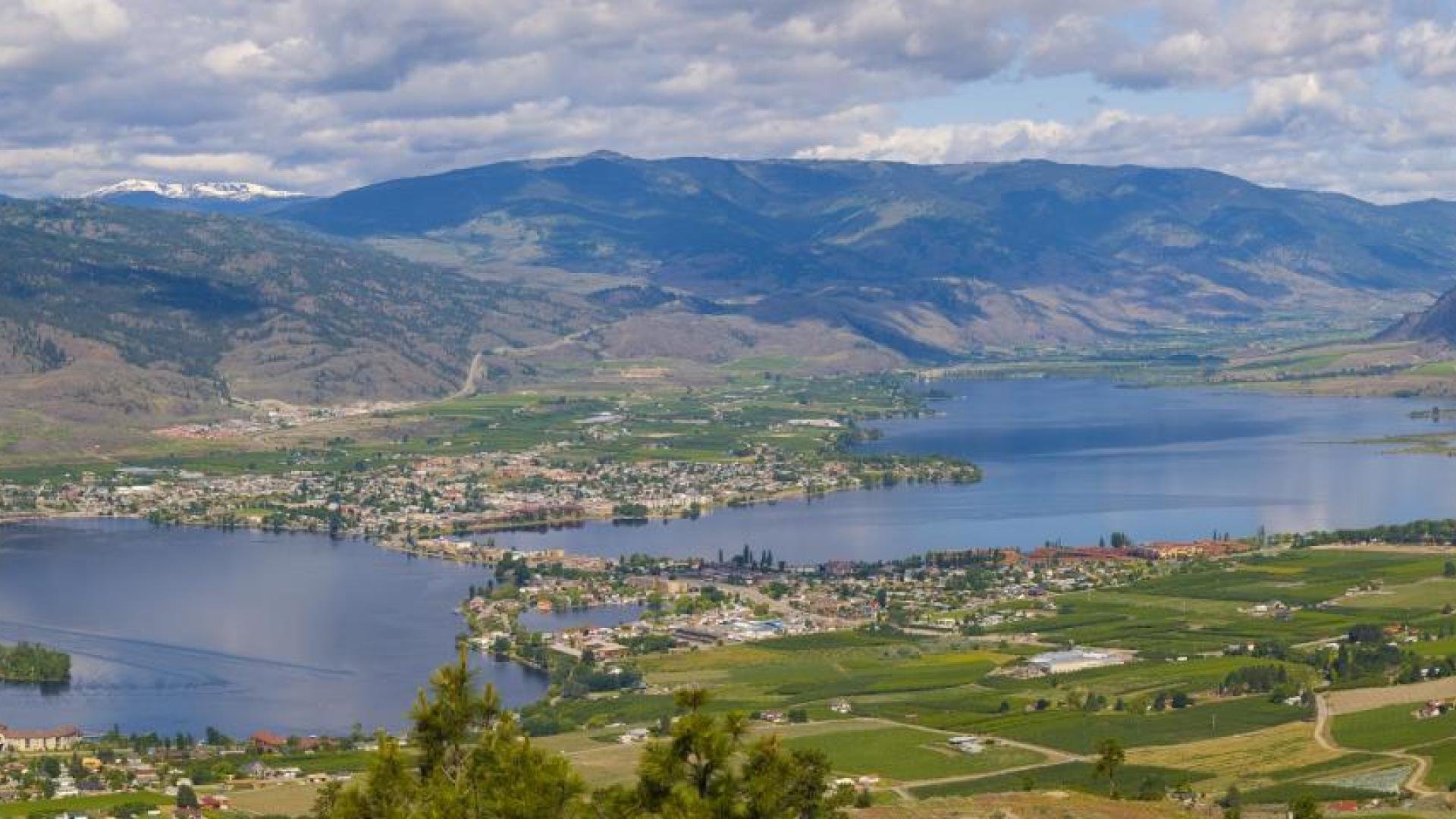
Osoyoos Lake, seen from Anarchist Mountain, straddles the Canada-U.S. border and is one of several southern B.C. waterways governed through cross-border arrangements.
Photo: International Joint Commission.
Nearly half a century before U.S. President Donald Trump ordered his government to call Lake Ontario “Lake America,” American officials tried to resolve another cross-border naming difference much closer to the Boundary, but Canada declined to make the change.
In 1980, the U.S. Board on Geographic Names proposed that Canada change the spelling of the Pend-d’Oreille River, which enters British Columbia from Washington and joins the Columbia River at Waneta, just south of Trail. Americans officially use Pend Oreille River, without the hyphens and apostrophe. The B.C. geographical names record says the U.S. proposal was rejected by the Geographical Names Board of Canada and the Canadian spelling was retained.
That history has new relevance after Trump signed an executive order Aug. 27 directing the U.S. government to rename Lake Ontario as Lake America for federal purposes. The order gave the U.S. secretary of the interior 30 days to carry out the change and directed federal maps, contracts, documents and communications to use the new name.
The change did not take 30 days. Later the same day, U.S. Secretary of the Interior Doug Burgum signed Secretary’s Order 3453, directing the Board on Geographic Names to act immediately and update the Geographic Names Information System. The order states that the U.S. federal name is changed from Lake Ontario to Lake America and that it took effect immediately.
On the Canadian side of the border, the official name remains Lake Ontario. As of Aug. 30, the Canadian Geographical Names Database continued to list Lake Ontario as the official name supplied by Ontario’s naming authority.
The disagreement has plenty of precedent in southern British Columbia, where rivers and lakes cross an international boundary while the two countries retain authority over the names they use within their own jurisdictions.
Canada controls Canadian place names
The Geographical Names Board of Canada is the national coordinating body for geographical naming, with federal, provincial and territorial departments and agencies responsible for names within their respective jurisdictions. Government of Canada maps and documents use the official forms adopted by those authorities.
In British Columbia, the BC Geographical Names Office has delegated authority under the Land Act to manage official names for geographical features including rivers, lakes and mountains. Those names appear on provincial and federal maps and charts and in official datasets.
The provincial office does not initiate new names or name changes. A formal proposal must be submitted before a change can be considered, and Canadian naming authorities make the decision within their jurisdictions. An American federal naming decision therefore does not, by itself, change an official Canadian name.
The Pend-d’Oreille provides one of the clearest local examples because authorities on the two sides have already considered whether their names should match.
Canada adopted Pend d’Oreille River in 1913 and changed the form to Pend-d’Oreille River in 1932. B.C.’s official record also identifies Pend Oreille River as the American spelling. When the U.S. Board on Geographic Names proposed in 1980 that Canada adopt the American form, the Canadian board rejected the proposal and retained its own spelling.
More than four decades later, the two names continue to coexist.
The Kootenay becomes the Kootenai
A much larger river provides another example. The Kootenay River begins in British Columbia, runs south through the Rocky Mountain Trench and crosses into Montana before turning northwest through Montana and Idaho. It then crosses the international boundary a second time, returning to B.C. near Creston before flowing through Kootenay Lake and eventually into the Columbia River at Castlegar.
In British Columbia, the official name is Kootenay River. In the United States, it is spelled Kootenai River.
B.C.’s geographical names record says Kootenay has been the province’s official spelling since 1864 and was adopted by the Geographic Board of Canada in 1900. The same provincial record identifies Kootenai as the spelling used in the United States.
The Okanagan provides another variation. In B.C., the waterway flowing south from Okanagan Lake through Osoyoos Lake is the Okanagan River. After it emerges from Osoyoos Lake in Washington, the channel continues to the Columbia under the American spelling Okanogan River. International Joint Commission records also distinguish between the Canadian and U.S. spellings.
The examples show that official names for a shared or connected geographical feature do not have to match on the two sides of the border.
Sometimes both countries choose the same name
There are also cases in which Canadian and American naming authorities deliberately adopted a common name.
Lake Koocanusa, the reservoir extending across the B.C.-Montana border behind Libby Dam, was officially named on June 17, 1968, by both the Canadian Permanent Committee on Geographical Names and the U.S. Board on Geographic Names.
The name itself was built around the international geography of the reservoir: Kootenay, Canada and USA were combined to create Koocanusa. The B.C. record says the name was the winning entry in a contest and was submitted by Alice Beers of Rexford, Montana.
The reservoir was created on the Kootenay — Kootenai in the United States — behind Libby Dam in Montana. Almost half of the roughly 85-mile reservoir lies in British Columbia, extending north from the border toward Wardner.
In the Boundary, the Kettle crosses twice
The international nature of the watershed is particularly visible around Grand Forks.
The Kettle River first crosses south from B.C. into Washington near Midway, then returns to Canada near Grand Forks. From there it flows through the Boundary before crossing into Washington again south of Christina Lake after receiving water from Christina Lake, eventually joining the Columbia River near Boyds, Washington.
Other local waterways make the same trip across the international line. Boundary Creek, west of Grand Forks, flows south into Washington and reaches the Kettle River there. B.C.’s geographical names record puts its total length at about 20 miles, with only its final quarter-mile in Washington.
July Creek, immediately west of Grand Forks, also flows south across the B.C.-Washington boundary. The provincial naming record says the stream is about eight miles long, with roughly 6.5 miles in British Columbia.
Those crossings mean that decisions affecting water levels, flows and water quality can have consequences on both sides of the border, regardless of which name appears on a national map.
More than a century of managing shared water
Canada and the United States signed the Boundary Waters Treaty in 1909, establishing principles and a mechanism for managing boundary and transboundary water issues and resolving disputes, particularly those involving water quantity and quality.
The treaty also established the International Joint Commission, which continues to oversee and advise on shared-water issues between the two countries.
Osoyoos Lake provides a particularly close example. The lake straddles the international boundary, while its water levels can be controlled under most conditions by Zosel Dam on the Okanogan River downstream in Washington.
The International Osoyoos Lake Board of Control dates to 1946 and oversees compliance with International Joint Commission orders governing the dam. The State of Washington Department of Ecology owns the current structure, with physical operation conducted by the Oroville and Tonasket Irrigation District under contract.
That system remains active this year. On May 12, the board declared drought conditions after forecasts indicated the hydrologic criteria used under the IJC’s 2013 supplementary order were likely to be met. Under drought conditions, Osoyoos Lake can be managed within a wider range of levels, giving operators greater flexibility to respond to ecological stream needs, irrigation and recreation.
The arrangement demonstrates that cooperation over a shared body of water does not depend on every geographical name being identical in both countries.
Lake Ontario remains Lake Ontario in Canada
The Aug. 27 U.S. orders now make Lake America the name used by the American federal government and direct the U.S. Board on Geographic Names to update its national system. Canada has made no corresponding change, and its official database continues to list the feature as Lake Ontario.
Southern B.C.’s border waterways show that such differences are neither unprecedented nor necessarily an obstacle to cross-border management. The Pend-d’Oreille has retained a Canadian spelling despite a direct U.S. request to change it, the Kootenay becomes the Kootenai south of the border, and the Okanagan continues in Washington as the Okanogan.
Those names are determined by the authorities on their respective sides of the international boundary, while the rivers and lakes themselves remain part of connected watersheds managed through more than a century of Canada-U.S. agreements and institutions.

The City of Trail is hosting National Day for Truth and Reconciliation programming at the Trail Riverfront Centre on Monday, Sept. 28 and Tuesday, Sept. 29, with the same three-hour program offered each afternoon