Evacuation orders ease across Southern Interior as wildfire recovery expands
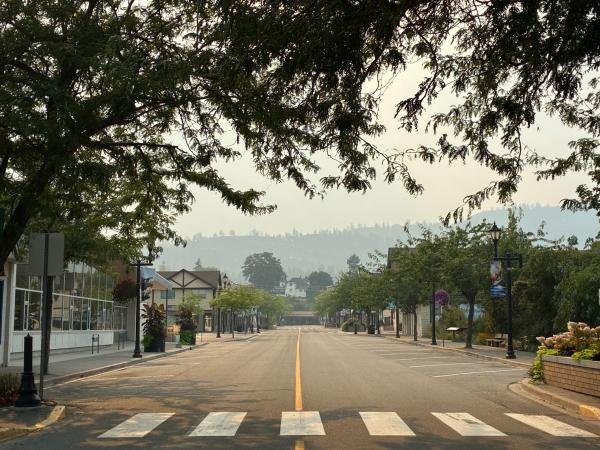
Downtown Summerland is seen during the Bald Range wildfire in August. Evacuation orders have continued to ease around the fire as communities move further into recovery.
Photo: Regional District of Okanagan-Similkameen
Wildfire conditions across the southern Interior have eased enough for more communities to move into recovery, but active fires, access restrictions and evacuation measures remain in parts of the Okanagan and West Kootenay.
Around the Bald Range wildfire west of Summerland, evacuation orders have continued to come down as residents return to affected areas. In the West Kootenay, the BC Wildfire Service has imposed an area restriction around the Ezra Creek wildfire northeast of Castlegar, while evacuation measures connected to the Bradley Creek wildfire have continued to ease in the North Okanagan.
The changes come days after the province ended the state of provincial emergency that had been declared Aug. 8 in response to significant wildfire activity and widespread evacuations. The province ended the declaration Aug. 27 but said the decision did not affect local evacuation orders, alerts or states of local emergency, and warned that wildfire risk remained elevated in parts of B.C.
Bald Range recovery continues
The Regional District of Okanagan-Similkameen said in an update Sunday that there were no longer any properties under evacuation order in Electoral Area F because of the Bald Range wildfire.
Properties in Faulder, South Meadow Valley and the Callan Road area that had remained under evacuation order were moved Saturday to Restricted Access Status. That allows residents with access permits to return to their properties to remove belongings, arrange insurance assessments, conduct cleanup and bring in contractors and utility providers while recovery operations continue.
The change does not mean all Bald Range evacuation measures have ended across every affected jurisdiction. The District of Summerland's current wildfire information still lists evacuation orders for certain properties, although the broader evacuation alerts for the community have been rescinded.
Princeton-Summerland Road also remains closed to through traffic, with access available to residents holding temporary access passes. Highway 5A and Highway 3 are being used as alternate routes.
The BC Wildfire Service established an area restriction around the Bald Range wildfire beginning at noon Aug. 29. The restriction is scheduled to remain in place until noon Sept. 12 unless it is rescinded earlier and is intended to protect the public and firefighters working in the area.
Recovery services are also shifting closer to affected communities. A Bald Range Wildfire Recovery Centre is scheduled to open Tuesday, Sept. 1, at Giant's Head School in Summerland and will operate Tuesday through Saturday from 10 a.m. to 5 p.m., providing information and resources for people affected by the fire.
The Emergency Support Services reception centre at the Penticton Trade and Convention Centre has closed, although telephone assistance remains available.
Area restriction remains around Ezra Creek wildfire
In the West Kootenay, crews continue to respond to the Ezra Creek wildfire northeast of Castlegar.
The BC Wildfire Service estimated the fire at 157 hectares on Aug. 29 and said it is suspected to have been caused by lightning. The fire was discovered Aug. 25 in the Ezra Creek area in Regional District of Central Kootenay Electoral Area I.
An area restriction covering Crown land around the fire took effect at noon Aug. 29 and is scheduled to remain until Oct. 15 unless it is rescinded earlier. The restriction includes areas reached through Lookout Road and the Sentinel Forest Service Road and is intended to keep the public away from active suppression operations.
The RDCK said in its latest wildfire bulletin that BC Wildfire Service had not recommended an evacuation alert or order for Ezra Creek. The regional district's current emergency page lists no evacuation alerts or orders anywhere in the RDCK.
The fire was estimated at about 200 hectares by the RDCK on Aug. 26, 150 hectares on Aug. 28 and 157 hectares by BC Wildfire Service on Aug. 29. The RDCK also reported Aug. 28 that crews and aviation resources were being used on the fire.
Earlier evacuation alerts connected to the Poplar Creek and Inonoaklin Creek wildfires were rescinded during the first week of August.
Bradley Creek evacuations continue to ease
Evacuation measures have also continued to ease around the Bradley Creek wildfire in the North Okanagan, although some measures remain in effect on Okanagan Indian Band lands.
The Regional District of North Okanagan rescinded its remaining evacuation alert for Electoral Area B on Aug. 24 and cancelled the state of local emergency associated with the fire.
Okanagan Indian Band has been carrying out a phased return for residents in affected areas. Another portion of its evacuation order was rescinded at 5 p.m. Aug. 28, covering a number of properties on Westside Road, Ta Ta Tlux Road and McMillan Drive, along with other areas identified on official evacuation maps.
EmergencyInfoBC's latest update continued to list evacuation orders and alerts on Okanagan Indian Band lands, while OKIB's current emergency information also lists active measures alongside the areas where orders have been partially rescinded.
OKIB has warned people returning to fire-affected properties to watch for hazards that can include unstable structures and trees, damaged utilities and ash.
A separate fire reported Aug. 26 on St. Anne's Hill on OKIB lands was contained later that afternoon, with crews remaining in the area to monitor it.
East Kootenay evacuation measures have ended
Conditions have improved considerably in the East Kootenay, where the Regional District of East Kootenay currently lists no evacuation orders or alerts.
The BC Wildfire Service rescinded the area restriction around the Jumbo Creek wildfire west of Invermere on Aug. 26 after fire behaviour and activity decreased. The fire was estimated at 1,136 hectares at the time.
BCWS cautioned that Jumbo Creek remains an active wildfire worksite and that hazards can persist inside burned areas after restrictions are removed, including unstable fire-damaged trees and hot ash pits.
No current emergency listed in the Boundary
The Regional District of Kootenay Boundary Emergency Operations Portal listed no current emergencies Sunday evening.
Although evacuation pressure has fallen substantially from earlier in August, provincial officials continue to caution that the wildfire season is not over. Local governments, First Nations and the BC Wildfire Service continue to manage active fires, access restrictions and recovery operations across the southern Interior.





Nine new outdoor pickleball courts opened at Glenmore Recreation Park on Oct. 8, expanding public recreation facilities in north Kelowna as construction continues on other parts of the park.