Where does the Kettle Valley Rail Trail actually go?
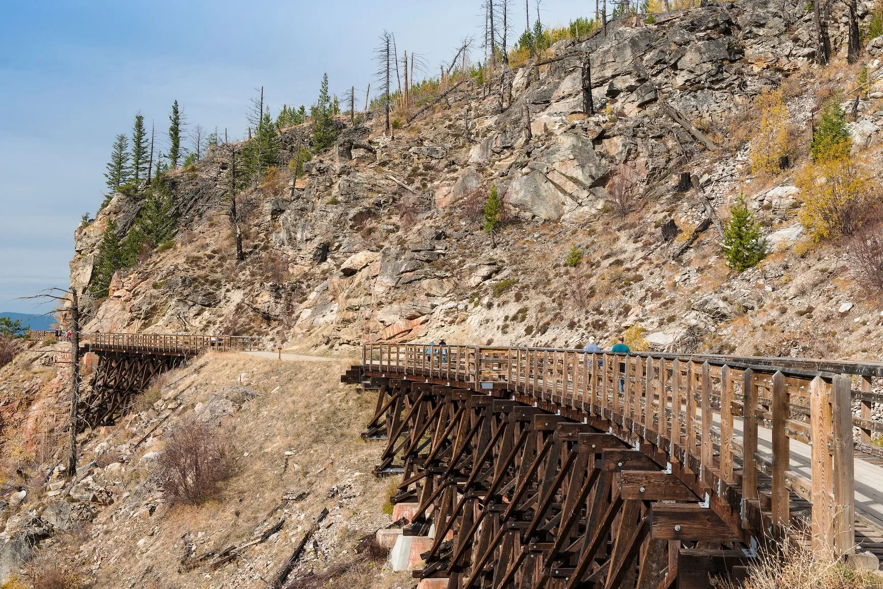
Myra Canyon Trestles along the former Kettle Valley Railway near Kelowna.
Photo: BC Parks
At the old railway station in Midway, B.C., a sign marks Mile 0 of the Kettle Valley Railway.
From here, the former railway heads west beside the Kettle River before turning north through the Boundary country around Westbridge and Beaverdell. Follow its historic route far enough and it climbs into the Okanagan Highlands, crosses Myra Canyon, reaches Penticton, heads back into the mountains toward Princeton and eventually descends through the Coquihalla to Hope.
There is a rail trail heading east from Midway, too. It runs through Greenwood, Grand Forks and Christina Lake and continues toward Castlegar, creating what looks on a modern trail map like one very long railway corridor across southern British Columbia.
That is where the terminology gets messy.
The historic Kettle Valley Railway, the recreational trails now commonly called the Kettle Valley Rail Trail, and the Trans Canada Trail overlap for hundreds of kilometres, but they are not the same thing. Even the boundaries of what people casually call the KVR have become blurred.
So where does the Kettle Valley Rail Trail actually begin and end?
The historical answer starts at Mile 0 in Midway and finishes near Hope. The precise railway endpoint was Odlum, a Canadian Pacific Railway point west of Hope, but Hope is the far more useful landmark for a modern traveller. The main line covered about 478 kilometres between the two communities.
The modern answer is considerably more complicated.
Mile 0 is in Midway
Midway sits near the U.S. border in B.C.'s Boundary region, about 55 kilometres by road west of Grand Forks. The original station house still stands at the Kettle River Museum, along with the original platform, railway exhibits and a restored Canadian Pacific caboose.
This is the actual Mile 0 of the Kettle Valley Railway, not a trail marker chosen after the tracks were removed.
By the time construction of the KVR began, another railway had already arrived in Midway from the east. The Columbia & Western Railway connected the Boundary mining district with the Canadian Pacific network, passing through Grand Forks and continuing toward what is now the Castlegar area.
The Kettle Valley Railway was built westward from Midway.
That direction was deliberate. A 1910 agreement between the Province of British Columbia and the railway company laid out a railway from Midway to Penticton as part of a larger plan to provide the Boundary District with a more direct Canadian rail connection to the Coast. Later agreements extended the project toward Princeton and Hope.
For today's traveller, Midway is therefore more than the eastern end of one abandoned railway. It is the point where two different railway histories meet.
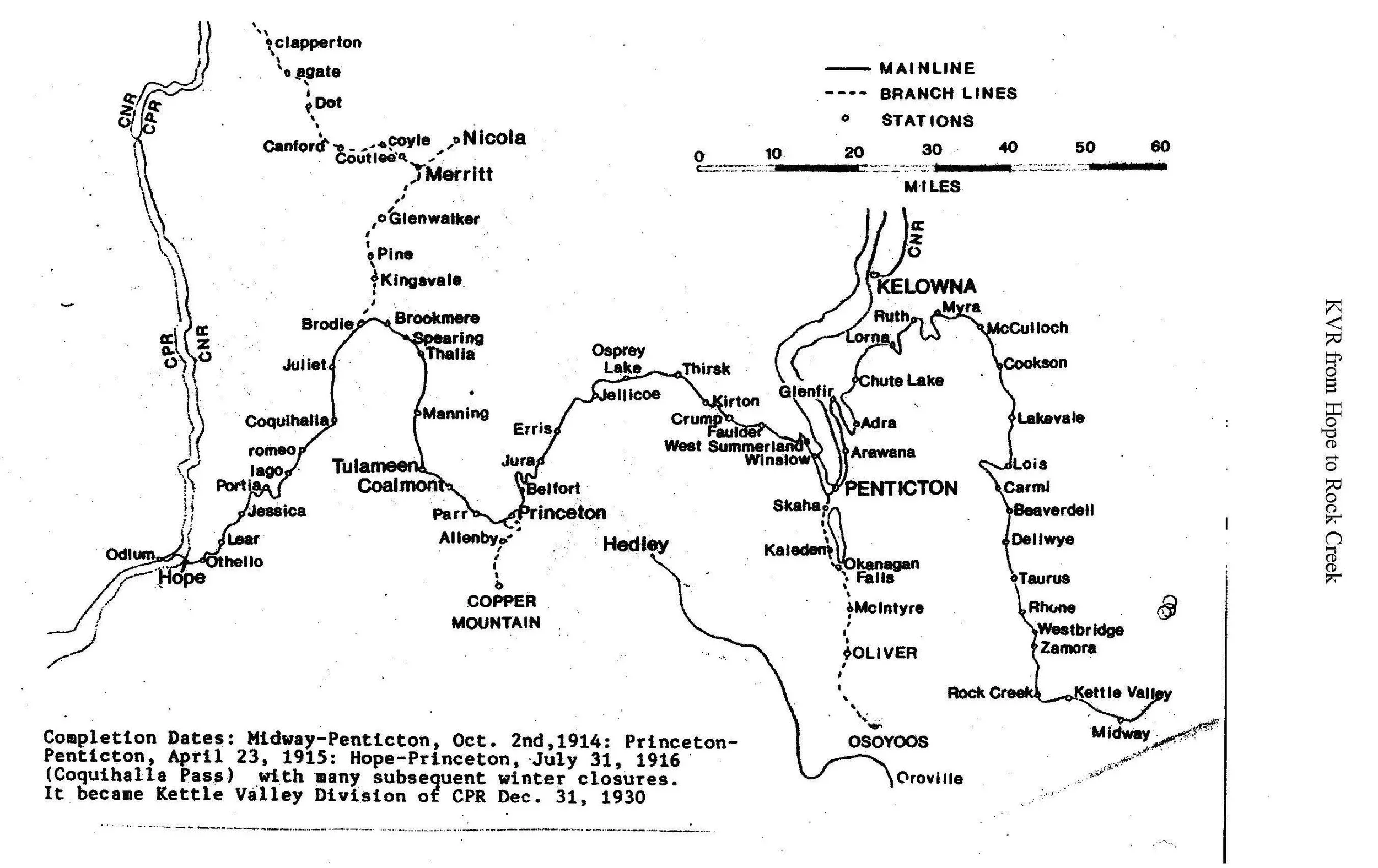
The historic Kettle Valley Railway ran west from Mile 0 at Midway through the Boundary, Okanagan and Similkameen before reaching Odlum, near Hope.
Map by Joe Smuin
From Midway into the Boundary
West of the station, the KVR followed the Kettle River country through places including Rock Creek before turning north along the West Kettle River through Westbridge and Beaverdell.
This is one of the less famous stretches of the route and, in places, it feels very different from the groomed gravel trail associated with Myra Canyon and Naramata. Parts of the old railway have been incorporated into roads or altered by later land use, and today's recreational route can move between gravel trail, dirt track and rural roads.
The old rail bed nonetheless remains easy to recognize in many places. Railway builders needed long, gradual approaches through mountainous country, so the route often follows rivers and hillsides rather than taking the more direct climbs familiar to motorists.
From Beaverdell, the railway climbed through the old Carmi subdivision toward McCulloch and the high country east of Kelowna. Historical station names along this stretch included Carmi, Lois, Lakevale, Cookson and McCulloch before the line reached Myra.
Today those names range from living communities to little more than points on old railway maps, giving this part of the KVR a different character from the busy Okanagan sections farther west.
Myra Canyon and the route to Penticton
Southeast of Kelowna, the railway entered Myra Canyon, where engineers carried the line across a succession of ravines using trestles, tunnels, rock cuts and carefully curved sections of track.
An 8.8-kilometre section through the canyon contains 16 wood-frame trestles, two steel bridges and two tunnels. The broader recreational route through Myra-Bellevue Park is now one of the best-known portions of the KVR, with a 12-kilometre trail between the Myra and June Springs access points. Cyclists can use the route, although BC Parks asks them to dismount and walk their bicycles across the trestles.
The railway continued beyond Myra through the high country around Chute Lake before beginning its descent toward Naramata and Penticton.
This is another stretch where the reason for the KVR's popularity as a recreational trail becomes obvious. The railway grade gives walkers and cyclists a gradual route through terrain that drops sharply toward Okanagan Lake, with the old industrial corridor now passing through a landscape of orchards and vineyards.
Penticton was a major operating centre for the railway, but geographically it was near the middle of the journey rather than the end. The historic line continued through the Trout Creek and Summerland area before heading back into the uplands toward Osprey Lake and Princeton.
For present-day trail users, however, this is also where the historic railway and the usable recreational trail separate in an important way.
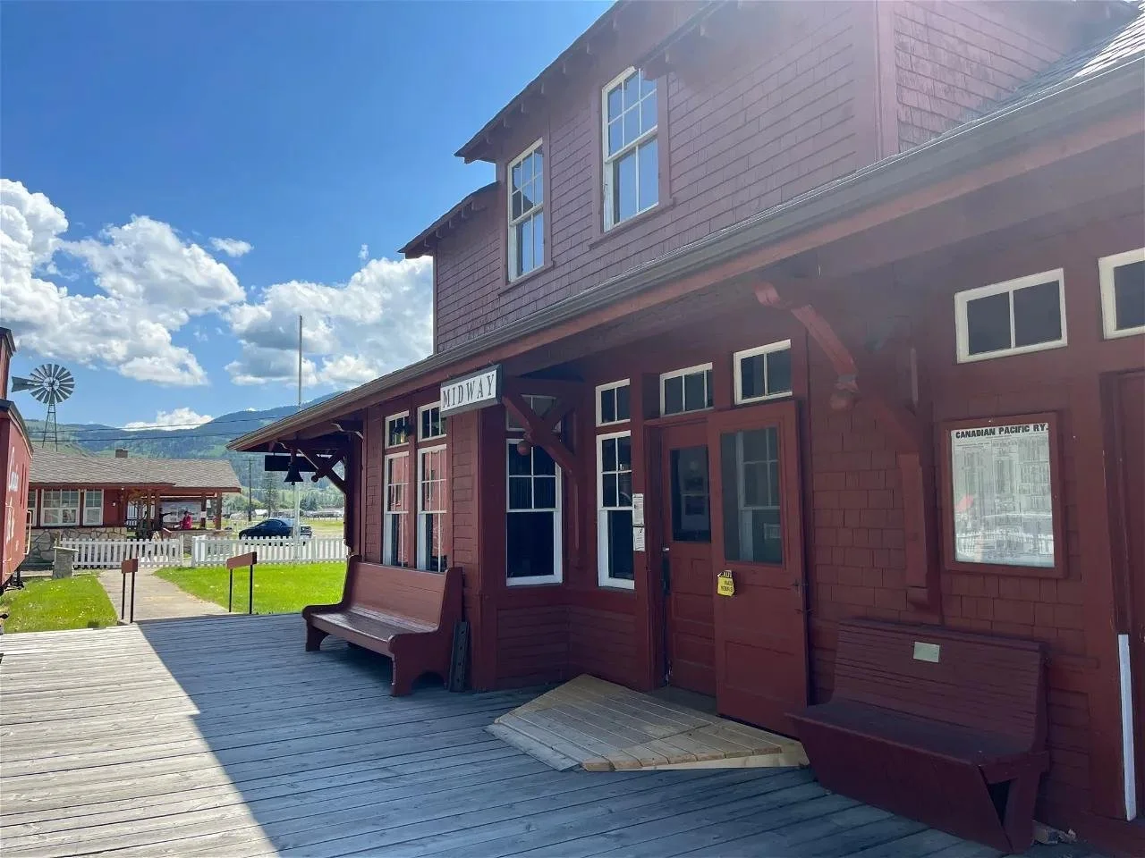
The original Midway station house now forms part of the Kettle River Museum at Mile 0 of the historic Kettle Valley Railway.
Photo credit Kettle River Museum
The KVR between Penticton and Summerland is closed
A portion of the former KVR corridor between Summerland and the Kaleden area is on land owned by the snpink'tn Indian Band.
That corridor is currently closed to all public access.
The Band first announced the closure in November 2025 following heavy rainfall that caused washouts, slope failures, rockfall and structural instability. In June 2026, snpink'tn, the City of Penticton, the District of Summerland and the Regional District of Okanagan-Similkameen jointly confirmed that the closure remained in effect between Summerland and Banbury Green.
The corridor is private Band-owned land, and visitors are asked not to enter it or bypass barriers and closure signs. The Channel walkway in Penticton is separate from the closed KVR corridor and remains open.
There is another reason the recreational route departs from the original railway around Summerland: part of the historic line is still a railway.
The Kettle Valley Steam Railway operates from Prairie Valley Station to the Trout Creek Trestle and back, using a surviving section of the old KVR. As of September 2026, the heritage railway is advertising the resumption of train service on Sept. 5.
Anyone tracing the KVR through this area therefore has to distinguish between the historic corridor, the active heritage railway, closed private land and the routes currently available to the public.
Across the Similkameen
Beyond Summerland, the historic railway climbed toward Osprey Lake before reaching Princeton.
From there it followed the Tulameen River country through Coalmont and Tulameen toward Brookmere. Near Brodie Siding, about seven kilometres west of Brookmere, the railway network once split in three directions: east toward Penticton, north toward Merritt and south toward Hope.
Brookmere still carries traces of that railway history, including an old water tower, but anyone planning to follow the KVR west from Princeton needs current information before setting out.
The atmospheric river that hit southern British Columbia in November 2021 severely damaged a 67-kilometre portion of the Kettle Valley Rail Trail between Princeton and the Coquihalla Highway. Flooding damaged trestles, retaining walls and culverts, washed away sections of trail bed and, in some places, shifted the river into the former trail corridor.
The section has remained closed since then.
In February 2026, the province initially announced plans to decommission the damaged corridor rather than rebuild it at an estimated cost of roughly $60 million, including future maintenance.
That plan changed several months later.
In June, the province announced that it would proceed with decommissioning infrastructure along a badly damaged 17-kilometre section near Coquihalla Lakes and Brookmere while considering repairs to three other priority areas: a bridge west of Princeton and access to Parr Tunnel and Whitesands Beach.
Those possible repairs still depend on federal funding and on arrangements for long-term maintenance.
The important point for travellers is simpler: the old rail grade is not currently a continuous through-route between Princeton and the Coquihalla.
The Province identifies an alternate Trans Canada Trail bypass around the damaged area, while work continues on longer-term trail connections.
Into the Coquihalla
Southwest of Brodie, the KVR entered the Coquihalla, the section of railway that did much to establish its reputation for difficult mountain engineering.
The line had to negotiate steep canyon walls, unstable slopes and severe winter weather on its way down toward Hope. Bridges and tunnels carried the railway through the Coquihalla Canyon, including the series now known as the Othello Tunnels.
The scenery came with a formidable maintenance bill. Snow and rockslides repeatedly disrupted operations, and a major washout on Nov. 23, 1959 was followed by numerous other failures. The line never reopened and was formally abandoned in July 1961.
The railway did not disappear completely from the landscape. Much of today's four-lane Coquihalla Highway was constructed along the former KVR rail bed, while other pieces survive as trails and historic sites.
At Coquihalla Canyon Park near Hope, visitors can again travel through the Othello Tunnels on a 3.5-kilometre round-trip trail. BC Parks currently allows cycling in designated areas but requires cyclists to dismount and walk through the tunnels.
From the canyon, the railway continued toward Hope before crossing the Fraser River and meeting the Canadian Pacific main line at Odlum, a former railway point west of town. Railway histories therefore use Midway-to-Odlum as the precise limits of the Kettle Valley Railway, while Midway-to-Hope remains the more recognizable description of the route.
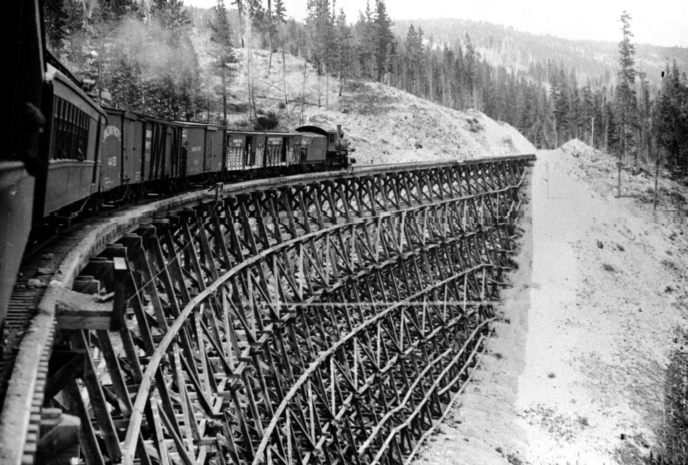
Mixed train crossing the Sirnach Creek trestle on the Kettle Valley Railway, circa 1916.
BC Archives, C-05830/Public Domain.
So why does the KVR sometimes appear to run through Grand Forks?
Return to the station in Midway and head the other way.
The rail trail east of Mile 0 passes through Boundary Falls and Greenwood, climbs toward Eholt and eventually reaches Grand Forks. From there the recreational corridor continues toward Christina Lake and Castlegar.
It is part of the same Trans Canada Trail network, which makes the transition almost invisible on many recreational maps. Historically, though, the railway beneath the trail has changed.
Trails BC marks the distinction explicitly: the Kettle Valley Railway ends at Midway and the former Columbia & Western Railway begins there, continuing east through the Boundary.
That difference is sometimes lost in tourism material, where “KVR” is used as a convenient name for a much larger connected rail-trail network. Some current visitor information, for example, describes a KVR route stretching all the way from Hope to Castlegar.
There is historical precedent for the looseness. A Kettle River Museum history project cites Boundary historian Kathleen Dewdney, who wrote in 1967 that some maps had already extended the Kettle Valley name far beyond the railway's actual limits. Through trains and the fame of the southern route helped turn “Kettle Valley Line” into a broader informal label.
Today's trail terminology inherited some of that ambiguity.
KVR, KVR Trail and Trans Canada Trail are not interchangeable
For anyone trying to read a map of southern B.C., it helps to separate three overlapping routes.
The Kettle Valley Railway is the historic railway. Its main line ran from Midway west through the Boundary, Okanagan, Similkameen and Coquihalla before reaching the Canadian Pacific connection near Hope.
The Kettle Valley Rail Trail consists of recreational trails that occupy surviving portions of that railway corridor. Some stretches closely follow the old rail bed; others have been interrupted by roads, active railway use, private land, flood damage or later development.
The Trans Canada Trail is the larger national trail network. It uses long sections of the former KVR, follows alternate routes where the original corridor is unavailable and continues east from Midway on the former Columbia & Western Railway.
That means there is no longer a single uninterrupted trail on which someone can simply leave Mile 0 in Midway and follow the old railway all the way to Hope.
What remains is a chain of railway landscapes connected by history: river valleys in the Boundary, the forested highlands around Carmi and McCulloch, the trestles of Myra Canyon, vineyard country above Okanagan Lake, the former railway towns west of Princeton and the tunnels and canyons of the Coquihalla.
Midway is one of the few places where the geography is especially easy to understand. Stand at the old station and the Kettle Valley Railway runs west. The rail corridor heading east belongs to the Columbia & Western.
More than a century after the first KVR construction crews arrived, Mile 0 still marks the point where those two railway stories meet.